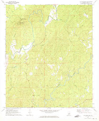
1971 Map of Flag Mountain
USGS Topo · Published 1973About this map
Weogufka State Forest anchors this survey of central Alabama, dominated by the prominent peak of Flagg Mountain. The terrain is defined by a dense network of waterways, including the winding Weogufka Creek and Hatchet Creek, which served as the primary geographical orienting points for the small rural communities and family homesteads of the early 1970s. The map illustrates a landscape of high ridges and deep hollows where localized settlements like Hillwood and Bentleyville grew around key intersections and water crossings.
Find a feature on this map
32 named features on this map. Tap any name to fly to it.
Don’t see what you’re looking for? This feature index may not catch every label — zoom into the map to look around manually.
Map Details
Editions of this 1971 Flag Mountain Map
2 editions found
Other maps of this area

1890 · Talladega
USGS Topo · 1:125,000

1892 · Talladega
USGS Topo · 1:125,000

1901 · Wetumpka
USGS Topo · 1:125,000

1903 · Wetumpka
USGS Topo · 1:125,000

1915 · Gantts Quarry
USGS Topo · 1:48,000

1917 · Gantts Quarry
USGS Topo · 1:62,500

1944 · Goodwater
USGS Topo · 1:62,500

1947 · Goodwater
USGS Topo · 1:62,500

1953 · Montgomery
USGS Topo · 1:250,000

1953 · Birmingham
USGS Topo · 1:250,000