
1943 Map of Flake
USGS Topo · Published 1953About this map
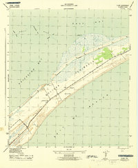
Bolivar Peninsula separates the churning waters of the Gulf of Mexico from the shallow reaches of East Bay and Galveston Bay in this mid-century survey. The landscape is defined by its maritime exposure, where narrow passages like Ladies Pass and Moodys Pass cut through coastal features such as Hannah Reef. The small settlement of Flake and the nearby Parrs Grove represent the sparse interior habitation of the time, while a Lookout Tower serves as a critical vantage point for the exposed coastline. Land use patterns are further revealed by the location of Port Bolivar Cem, situated away from the marshy shoreline. To the southwest, Oyster Lake provides a protected pocket of water, illustrating the intricate shoreline geometry of this Texas coastal barrier before more modern developments transformed the peninsula.
Find a feature on this map
20 named features on this map. Tap any name to fly to it.
Don’t see what you’re looking for? This feature index may not catch every label — zoom into the map to look around manually.
Map Details
Editions of this 1943 Flake Map
2 editions found
Historical Maps of Galveston Through Time
49 maps found

1929 Algoa
Galveston County, TX

1929 Karankawa Lake
Galveston County, TX

1929 Virginia Point
Galveston County, TX

1931 Flake
Galveston County, TX

1931 Lake Como
Galveston County, TX

1932 Algoa
Galveston County, TX

1932 Bolivar Point
Galveston County, TX

1932 Virginia Point
Galveston County, TX

1933 Bolivar Point
Galveston County, TX

1933 Caplen
Galveston County, TX

1933 Carancahua Lake
Galveston County, TX

1933 Flake
Galveston County, TX

1933 Lake Como
Galveston County, TX

1933 San Luis Pass
Galveston County, TX

1933 The Jetties
Galveston County, TX

1943 Caplen
Galveston County, TX

1943 Carancahua Lake
Galveston County, TX
1943 Flake
Galveston County, TX

1943 Lake Como
Galveston County, TX

1943 Port Bolivar
Galveston County, TX

1943 San Luis Pass
Galveston County, TX

1943 The Jetties
Galveston County, TX

1943 Virginia Point
Galveston County, TX

1954 Caplen
Galveston County, TX

1954 Flake
Galveston County, TX

1954 Lake Como
Galveston County, TX

1954 Port Bolivar
Galveston County, TX

1954 The Jetties
Galveston County, TX

1954 Virginia Point
Galveston County, TX

1956 Algoa
Galveston County, TX

1963 San Luis Pass
Galveston County, TX

1963 Sea Isle
Galveston County, TX

1994 Caplen
Galveston County, TX

1994 Flake
Galveston County, TX

1994 Lake Como
Galveston County, TX

1994 Port Bolivar
Galveston County, TX

1994 The Jetties
Galveston County, TX

1994 Virginia Point
Galveston County, TX

1995 Virginia Point
Galveston County, TX

2022 Algoa
Galveston County, TX

2022 Port Bolivar
Galveston County, TX

2022 Virginia Point
Galveston County, TX

2025 Caplen
Galveston County, TX

2025 Flake
Galveston County, TX

2025 Galveston OE S
Galveston County, TX

2025 Lake Como
Galveston County, TX

2025 San Luis Pass
Galveston County, TX

2025 Sea Isle
Galveston County, TX

2025 The Jetties
Galveston County, TX