1955 Map of Flat Gap
USGS Topo · Published 1965About this map
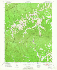
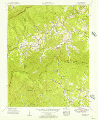
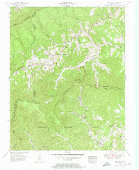
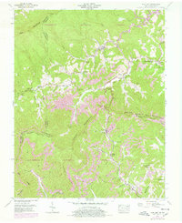
Pine Mountain and Black Mountain dominate this mid-century landscape where the Kentucky-Virginia state line follows the high ridges. This 1955 survey captures the rural character of the region before significant modernization, centered on the Letcher County-Wise County boundary. Small rural communities like Gilley, Flat Gap, and Dixiana are situated along the valley floors, connected by a network of creeks including the Pound River and Guest River. The map provides a detailed view of social infrastructure in the Appalachian highlands, marking several local educational and religious centers. Notable landmarks such as Cane Patch Church, Marthas Chapel, and the Hantsucker Sch illustrate the settlement patterns of families living along the winding forks of Laurel Fork and Phillips Creek. The inclusion of family-named features like Bolling Cem and Addington Cem offers valuable insights for those researching the genealogy of the area within the Jefferson National Forest.
Find a feature on this map
57 named features on this map. Tap any name to fly to it.
Don’t see what you’re looking for? This feature index may not catch every label — zoom into the map to look around manually.
Map Details
Editions of this 1955 Flat Gap Map
5 editions found

Other maps of this area

1890 · Whitesburg
USGS Topo · 1:125,000

1892 · Whitesburg
USGS Topo · 1:125,000

1894 · Estillville
USGS Topo · 1:125,000

1912 · Pound
USGS Topo · 1:48,000

1913 · Oven Fork
USGS Topo · 1:48,000

1914 · Pound
USGS Topo · 1:62,500

1915 · Whitesburg
USGS Topo · 1:62,500

1920 · Wise
USGS Topo · 1:48,000

1921 · Big Stone Gap
USGS Topo · 1:48,000

1921 · Wise
USGS Topo · 1:62,500