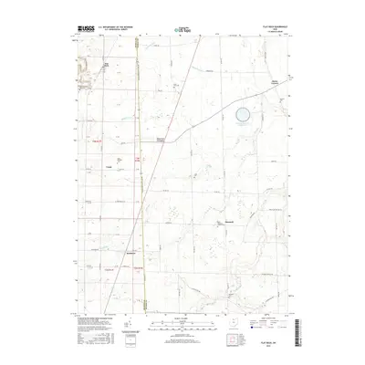
2016 Map of Flat Rock
USGS Topo · Published 2016About this map
Sherman Township and the surrounding countryside of the Ohio agricultural belt are defined here by a network of crossroads settlements and historic parish grounds. The landscape is oriented along the Seneca Co Huron Co line, where the village of Frank and the community of Reedtown sit just west of the boundary. The map reveals a high density of rural cemeteries and religious sites, such as Saint Sebastian Catholic Cem and Saint Michaels Cem, which serve as vital markers for genealogical research in these long-established farming communities. Water management is a critical feature of this terrain, evidenced by the presence of Bellevue Reservoir Number Five and a system of drainage including Hayward Ditch and the winding course of Frink Run. The layout of local roads like Old Military Rd and Huron-Seneca Co Line Rd provides a look at the historical transit patterns that connected these hamlets.
Find a feature on this map
79 named features on this map. Tap any name to fly to it.
Don’t see what you’re looking for? This feature index may not catch every label — zoom into the map to look around manually.
Map Details
Editions of this 2016 Flat Rock Map
This is the sole edition of this map. No revisions or reprints were ever made.
Other maps of this area

1901 · Bellevue
USGS Topo · 1:62,500

1903 · Bellevue
USGS Topo · 1:62,500

1904 · Sandusky
USGS Topo · 1:62,500

1915 · Norwalk
USGS Topo · 1:62,500

1915 · Siam
USGS Topo · 1:62,500

1944 · Norwalk
USGS Topo · 1:62,500

1956 · Toledo
USGS Topo · 1:250,000

1959 · Kimball
USGS Topo · 1:24,000
1959 · Bellevue
USGS Topo · 1:24,000
1959 · Clyde
USGS Topo · 1:24,000