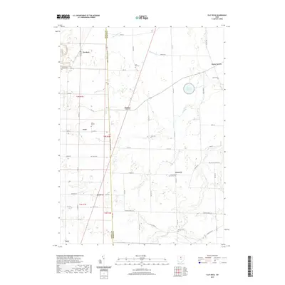
2019 Map of Flat Rock
USGS Topo · Published 2019About this map
The boundary between Seneca and Huron counties follows the Huron-Seneca Co Line Rd, dividing a landscape shaped by agricultural drainage and small rural settlements. This survey captures a network of crossroad communities including Flat Rock, Reedtown, and Bismarck, many centered around historic parish grounds and cemeteries. The industrial presence of the Wheeling and Lake Erie railroad cuts through the terrain, connecting this farming region to broader markets. Water management is a defining characteristic of the area, evidenced by the channelized Hayward Ditch and the proximity of the Bellevue Reservoir. Local genealogy is well-represented through numerous burial sites like Saint Pauls Cem and Saint-Sebastian Catholic Cem, which reflect the community's early settlement patterns. Historical transit is preserved in the naming of Old Military Rd, hinting at the area's strategic logistical past before the modern paving of routes like Co Hwy 30.
Find a feature on this map
62 named features on this map. Tap any name to fly to it.
Don’t see what you’re looking for? This feature index may not catch every label — zoom into the map to look around manually.
Map Details
Editions of this 2019 Flat Rock Map
This is the sole edition of this map. No revisions or reprints were ever made.
Other maps of this area

1901 · Bellevue
USGS Topo · 1:62,500

1903 · Bellevue
USGS Topo · 1:62,500

1904 · Sandusky
USGS Topo · 1:62,500

1915 · Norwalk
USGS Topo · 1:62,500

1915 · Siam
USGS Topo · 1:62,500

1944 · Norwalk
USGS Topo · 1:62,500

1956 · Toledo
USGS Topo · 1:250,000

1959 · Kimball
USGS Topo · 1:24,000
1959 · Bellevue
USGS Topo · 1:24,000
1959 · Clyde
USGS Topo · 1:24,000