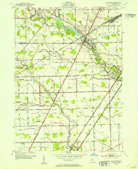
1952 Map of Flat Rock
USGS Topo · Published 1953About this map
Flat Rock and Rockwood serve as the primary hubs along the winding course of the Huron River, marking a period of postwar expansion where industrial infrastructure met rural landscapes. The Pennsylvania RR and New York Central RR lines cut a diagonal path across the terrain, supporting the Flat Rock Yard and facilitating the movement of goods between Detroit and Toledo. This transit-heavy corridor is balanced by extensive drainage networks, such as Swan Creek and Silver Creek, which define the agricultural outskirts in Ash and Huron townships.
Find a feature on this map
56 named features on this map. Tap any name to fly to it.
Don’t see what you’re looking for? This feature index may not catch every label — zoom into the map to look around manually.
Map Details
Editions of this 1952 Flat Rock Map
2 editions found
Other maps of this area

1906 · Wyandotte
USGS Topo · 1:62,500

1906 · Romulus
USGS Topo · 1:62,500

1912 · Wyandotte
USGS Topo · 1:62,500

1912 · Monroe
USGS Topo · 1:62,500

1914 · Monroe
USGS Topo · 1:62,500

1927 · Monroe
USGS Topo · 1:31,680

1928 · Romulus
USGS Topo · 1:62,500

1929 · Wyandotte
USGS Topo · 1:62,500

1936 · Wyandotte
USGS Topo · 1:31,680
1936 · Belleville
USGS Topo · 1:31,680
Featured Places
- Brownstown Charter Township, MI
- Frenchtown Charter Township, MI
- Huron Charter Township, MI
- Woodhaven, MI
- Berlin Charter Township, MI