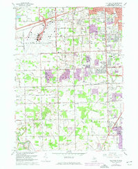
1967 Map of Flat Rock NE
USGS Topo · Published 1974About this map
Detroit Metropolitan-Wayne County Airport dominates the northwest quadrant of this Wayne County landscape, showing the massive facility during a period of significant regional expansion. The surrounding areas of Taylor and Woodhaven exhibit the rapid suburbanization of the late 1960s and early 1970s, as residential grids began to overlay the former farmsteads of Brownstown. A complex network of drainage systems, such as the Blakely Drain and Hale Drain, crisscrosses the low-lying terrain toward the Huron River. This survey captures a transitional moment where community hubs like Taylor Center were being reshaped by the Detroit Industrial and Western Freeway. Researchers can find numerous local institutions from this era, including Taylor Center High Sch and John F Kennedy Sch, alongside older landmarks like the West Mound Cem.
Find a feature on this map
97 named features on this map. Tap any name to fly to it.
Don’t see what you’re looking for? This feature index may not catch every label — zoom into the map to look around manually.
Map Details
Editions of this 1967 Flat Rock NE Map
Other maps of this area

1905 · Wayne
USGS Topo · 1:62,500

1905 · Detroit
USGS Topo · 1:62,500

1906 · Wyandotte
USGS Topo · 1:62,500

1906 · Romulus
USGS Topo · 1:62,500

1912 · Wyandotte
USGS Topo · 1:62,500

1912 · Wayne
USGS Topo · 1:62,500

1918 · Detroit
USGS Topo · 1:62,500

1924 · Detroit
USGS Topo · 1:62,500

1928 · Romulus
USGS Topo · 1:62,500

1929 · Wyandotte
USGS Topo · 1:62,500