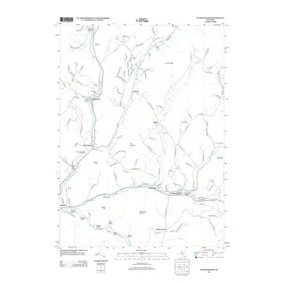
2013 Map of Fleischmanns
USGS Topo · Published 2013About this map
Fleischmanns and the surrounding high Catskill terrain define this landscape, where the Bush Kill joins the E Br Delaware River. The map documents a complex network of narrow valleys and hollows, including Meeker Hollow, Bragg Hollow, and Andrus Hollow, which have dictated the path of local development for generations. Small settlements like Halcottsville and Arkville are positioned at critical water junctions, while higher elevations are marked by landmarks like Fleischmann Mountain and Hog Mountain.
Find a feature on this map
146 named features on this map. Tap any name to fly to it.
Don’t see what you’re looking for? This feature index may not catch every label — zoom into the map to look around manually.
Map Details
Editions of this 2013 Fleischmanns Map
This is the sole edition of this map. No revisions or reprints were ever made.
Other maps of this area

1900 · Phoenicia
USGS Topo · 1:62,500

1901 · Margaretville
USGS Topo · 1:62,500

1901 · Gilboa
USGS Topo · 1:62,500

1903 · Gilboa
USGS Topo · 1:62,500

1903 · Phoenicia
USGS Topo · 1:62,500

1904 · Hobart
USGS Topo · 1:62,500

1904 · Margaretville
USGS Topo · 1:62,500
1945 · Seager
USGS Topo · 1:24,000

1945 · West Kill
USGS Topo · 1:24,000

1945 · Fleischmanns
USGS Topo · 1:24,000