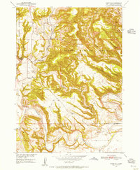
1950 Map of Flint Hill
USGS Topo · Published 1956About this map
The Cheyenne River cuts through the southern reaches of this landscape, framing a terrain of deep canyons and high ridges within the Harney National Forest. The Chicago Burlington and Quincy railroad tracks navigate the winding path of Chilson Canyon, providing a vital transportation artery through the Black Hills region. This survey captures a rural landscape where isolated outposts like Marty Ranch, Conboys Ranch, and Gull Ranch represent the ranching heritage of Fall River County. A notable sign of shifting community patterns is the Gull Sch (Abandoned), which stands alongside the railroad near Chilson Station. The map's high-resolution contour lines reveal the complex drainage systems of Hell Canyon, Wildcat Canyon, and Brady Canyon, while land use is further evidenced by a solitary Oil Well and several windmills scattered across the high ground.
Find a feature on this map
26 named features on this map. Tap any name to fly to it.
Don’t see what you’re looking for? This feature index may not catch every label — zoom into the map to look around manually.
Map Details
Editions of this 1950 Flint Hill Map
3 editions found
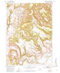
Other maps of this area

1902 · Edgemont
USGS Topo · 1:125,000

1950 · Edgemont
USGS Topo · 1:24,000

1950 · Heppner
USGS Topo · 1:24,000

1950 · Cascade Springs
USGS Topo · 1:24,000

1950 · Rumford
USGS Topo · 1:24,000

1950 · Edgemont NE
USGS Topo · 1:24,000

1950 · Minnekahta
USGS Topo · 1:24,000

1950 · Flint Hill
USGS Topo · 1:24,000

1951 · Minnekahta NE
USGS Topo · 1:24,000

1955 · Hot Springs
USGS Topo · 1:250,000