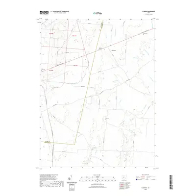
2019 Map of Florence
USGS Topo · Published 2019About this map
The Little Miami River and its tributaries carve a network through this agricultural landscape along the boundary of Clark and Madison counties. The small settlement of Florence sits near the intersection of several regional routes, including the Columbus Cincinnati Rd and Neil Rd. This area is defined by its extensive drainage system, where numerous man-made channels like Jones Ditch, Woosley Ditch, and Westwater Ditch supplement natural flows like Paint Creek and Sugar Cr. For genealogists and local historians, the landscape is dotted with several smaller burial grounds, such as Williams Chapel Cem, Pancake Cem, and the Infirmary Cem, which point to early pioneer family plots and community institutions in Stokes Township.
Find a feature on this map
56 named features on this map. Tap any name to fly to it.
Don’t see what you’re looking for? This feature index may not catch every label — zoom into the map to look around manually.
Map Details
Editions of this 2019 Florence Map
This is the sole edition of this map. No revisions or reprints were ever made.
Other maps of this area

1906 · Mt Sterling
USGS Topo · 1:62,500

1907 · London
USGS Topo · 1:62,500

1907 · South Charleston
USGS Topo · 1:62,500

1916 · Octa
USGS Topo · 1:62,500

1944 · Octa
USGS Topo · 1:62,500

1947 · Columbus
USGS Topo · 1:250,000

1961 · Columbus
USGS Topo · 1:250,000
1961 · Vienna
USGS Topo · 1:24,000
1961 · New Moorefield
USGS Topo · 1:24,000
1961 · London
USGS Topo · 1:24,000