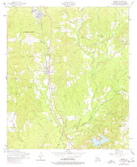
1954 Map of Florien
USGS Topo · Published 1977About this map
The Kansas City Southern railroad corridor dictates the settlement pattern of this Sabine Parish landscape, connecting the timber-focused community of Fisher in the north to the town of Florien. This mid-century survey reveals a transition in the local timber industry, evidenced by several sections of dismantled railroad winding through the creek drainages. Much of the northwestern portion lies within the historic La Nana Grant, where smaller family and community landmarks like Lewing Cemetery and Lewing Chapel reside. The landscape is deeply dissected by a dense network of waterways, including Toro Bayou and Midkiff Creek, which defined the placement of rural centers. To the south and east, small community hubs like Gandy and Mt. Carmel are anchored by social institutions such as Plainview School and Cypress Toro Church, reflecting the area's established rural social fabric during the 1950s.
Find a feature on this map
48 named features on this map. Tap any name to fly to it.
Don’t see what you’re looking for? This feature index may not catch every label — zoom into the map to look around manually.
Map Details
Editions of this 1954 Florien Map
2 editions found
Other maps of this area

1941 · Zwolle
USGS Topo · 1:62,500

1942 · Many
USGS Topo · 1:62,500

1942 · Florien
USGS Topo · 1:62,500

1943 · Many
USGS Topo · 1:62,500

1944 · Negreet
USGS Topo · 1:62,500

1944 · Florien
USGS Topo · 1:62,500

1944 · Zwolle
USGS Topo · 1:62,500

1953 · Alexandria
USGS Topo · 1:250,000

1954 · Toro
USGS Topo · 1:24,000

1954 · Florien
USGS Topo · 1:62,500