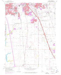
1968 Map of Florin
USGS Topo · Published 1977About this map
Sacramento urban expansion pushes southward into the drainage basins of Morrison Creek and Laguna Creek during the late 1960s and 1970s. This survey illustrates the transformation of pastoral lands into residential corridors, with numerous schools such as Burbank High School and Goethe Junior High School established to serve growing neighborhoods. The transit landscape is defined by the parallel routes of the Southern Pacific and Western Pacific railroads, which cut through the territory near Florin and Franklin. Significant local landmarks include the Southgate Shopping Center and large recreational tracts like the Valley Hi Country Club. For genealogists, the map preserves the locations of the San Joaquin Cemetery and Masonic Cemetery, while the western edge reaches the banks of the Sacramento River at Freeport.
Find a feature on this map
57 named features on this map. Tap any name to fly to it.
Don’t see what you’re looking for? This feature index may not catch every label — zoom into the map to look around manually.
Map Details
Editions of this 1968 Florin Map
3 editions found
Other maps of this area

1891 · Sacramento
USGS Topo · 1:125,000

1892 · Sacramento
USGS Topo · 1:125,000

1893 · Sacramento
USGS Topo · 1:125,000

1894 · Lodi
USGS Topo · 1:125,000

1902 · Fairoaks
USGS Topo · 1:62,500

1907 · Davisville
USGS Topo · 1:62,500

1908 · Courtland
USGS Topo · 1:62,500

1909 · Elk Grove
USGS Topo · 1:31,680

1909 · Florin
USGS Topo · 1:31,680

1910 · Bruceville
USGS Topo · 1:31,680