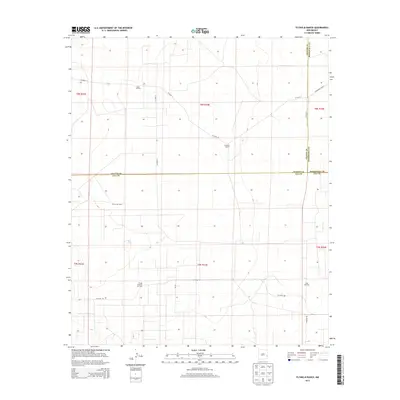
2013 Map of Flying M Ranch
USGS Topo · Published 2013About this map
The Flying M Ranch dominates this high plains landscape at the intersection of Lea, Chaves, and Roosevelt counties. This 2013 survey reveals an economy deeply tied to both traditional ranching and the petroleum industry, with the Tobac Oil Field, Flying M South Oil Field, and Vada Oil Field scattered across the township and range sections. The presence of features like Mill on the Fence and the East Tank underscore the critical importance of water management in this arid environment. Transportation is defined by a sparse grid of county roads, including Co Road 43 and Co Road 170, which connect remote ranching headquarters and oil production sites across the vast, relatively flat terrain of eastern New Mexico.
Find a feature on this map
21 named features on this map. Tap any name to fly to it.
Don’t see what you’re looking for? This feature index may not catch every label — zoom into the map to look around manually.
Map Details
Editions of this 2013 Flying M Ranch Map
This is the sole edition of this map. No revisions or reprints were ever made.
Other maps of this area

1954 · Brownfield
USGS Topo · 1:250,000

1958 · Brownfield
USGS Topo · 1:250,000

1961 · Johnson Ranch
USGS Topo · 1:24,000

1962 · Brownfield
USGS Topo · 1:250,000

1970 · Johnson Ranch
USGS Topo · 1:24,000

1972 · Milnesand SW
USGS Topo · 1:24,000
1972 · Milnesand NW
USGS Topo · 1:24,000

1973 · Caprock
USGS Topo · 1:24,000
1973 · Lane Salt Lake
USGS Topo · 1:24,000

1978 · Flying M Ranch
USGS Topo · 1:24,000