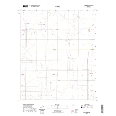
2020 Map of Flying M Ranch
USGS Topo · Published 2020About this map
Flying M Ranch sits as the central landmark in this corner of the Llano Estacado, where the borders of Lea, Chaves, and Roosevelt Counties converge. The landscape is defined by a sparse but essential network of rural routes, including Ledoux Rd and Tobac Rd, which connect isolated ranching outposts across the high plains. Surveyed by the U.S. Geological Survey, the map documents the Public Land Survey System grid that organized this region into townships such as t8s r33e and t9s r33e. The terrain is characterized by subtle elevation changes and numerous small depressions, typical of the eastern New Mexico plateau where water management and road access dictated the patterns of settlement and livestock operations.
Find a feature on this map
17 named features on this map. Tap any name to fly to it.
Don’t see what you’re looking for? This feature index may not catch every label — zoom into the map to look around manually.
Map Details
Editions of this 2020 Flying M Ranch Map
This is the sole edition of this map. No revisions or reprints were ever made.
Other maps of this area

1954 · Brownfield
USGS Topo · 1:250,000

1958 · Brownfield
USGS Topo · 1:250,000

1961 · Johnson Ranch
USGS Topo · 1:24,000

1962 · Brownfield
USGS Topo · 1:250,000

1970 · Johnson Ranch
USGS Topo · 1:24,000

1972 · Milnesand SW
USGS Topo · 1:24,000
1972 · Milnesand NW
USGS Topo · 1:24,000

1973 · Caprock
USGS Topo · 1:24,000
1973 · Lane Salt Lake
USGS Topo · 1:24,000

1978 · Flying M Ranch
USGS Topo · 1:24,000