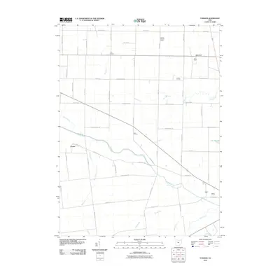
2010 Map of Foraker
USGS Topo · Published 2010About this map
The Scioto River winds through this agricultural portion of Hardin County, anchoring a landscape defined by its waterways and straight-line rural road network. Small settlements like Foraker and Blanchard are situated among a series of drainage systems including Hog Creek, Fourmile Run, and Cessna Creek. The area's history is preserved in localized burial grounds such as Smith Cemetery, Cessna Cemetery, and Fulton Cemetery, while Potters Field serves as a reminder of the county's social history. Industrial activity is evident at the Hardin Quarry, and local aviation is represented by Hardin Airport and Eibling Circle E Airport. Recreational and natural features like Lake Idlewild and Silver Creek break the geometric pattern of township roads, illustrating the persistent influence of the river basin on this Midwestern farming region during the early 21st century.
Find a feature on this map
48 named features on this map. Tap any name to fly to it.
Don’t see what you’re looking for? This feature index may not catch every label — zoom into the map to look around manually.
Map Details
Editions of this 2010 Foraker Map
This is the sole edition of this map. No revisions or reprints were ever made.
Other maps of this area

1905 · Arlington
USGS Topo · 1:62,500

1907 · Bluffton
USGS Topo · 1:62,500

1907 · Arlington
USGS Topo · 1:24,000

1913 · Alger
USGS Topo · 1:48,000

1915 · Alger
USGS Topo · 1:62,500

1915 · Kenton
USGS Topo · 1:62,500

1943 · Alger
USGS Topo · 1:62,500

1944 · Kenton
USGS Topo · 1:62,500

1950 · Marion
USGS Topo · 1:250,000
1960 · Roundhead
USGS Topo · 1:24,000