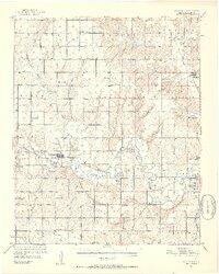
1951 Map of Fort Cobb
USGS Topo · Published 1952About this map
The Washita River meanders through the heart of Caddo County in this early 1950s survey, documenting a landscape defined by its rural schools and historic missions. The town of Fort Cobb serves as a central hub along the Chicago Rock Island and Pacific railroad, which follows the river valley east toward Gracemont. This era reveals a high density of local educational and religious institutions serving the agricultural community, including the Riverside Indian Sch and St Patricks Indian Mission near the eastern edge. Smaller settlements and geographic markers like Apache Wye and Albert are interconnected by a network of creeks, such as Cobb Creek and Sugar Creek. The distribution of family and community landmarks, from the New Salem Sch to the Redstone Mission, provides a detailed look at the social geography of the Oklahoma plains before later consolidation altered the rural school system.
Find a feature on this map
51 named features on this map. Tap any name to fly to it.
Don’t see what you’re looking for? This feature index may not catch every label — zoom into the map to look around manually.
Map Details
Editions of this 1951 Fort Cobb Map
5 editions found
Other maps of this area

1893 · Buggy Creek
USGS Topo · 1:62,500

1945 · Anadarko
USGS Topo · 1:62,500

1949 · Cement
USGS Topo · 1:62,500

1950 · Saddle Mountain
USGS Topo · 1:62,500

1951 · Binger
USGS Topo · 1:62,500

1951 · Fort Cobb
USGS Topo · 1:62,500

1955 · Lawton
USGS Topo · 1:250,000

1955 · Clinton
USGS Topo · 1:250,000

1956 · Alden
USGS Topo · 1:24,000

1956 · Boone
USGS Topo · 1:24,000