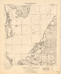
1921 Map of Fort De Soto
USGS Topo · Published 1921About this map
Fort De Soto and the surrounding islands of the lower Gulf Coast are captured here just after the First World War, when much of the region remained dominated by coastal wetlands and scattered agricultural settlements. The strategic importance of the mouth of Tampa Bay is evident through maritime navigation markers like the Beacon and Indian Hill Beacon, as well as the U.S. Quarantine Station on Mullet Key. On the mainland, the Seaboard Air Line railroad ties together riverfront communities like Palmetto, Ellenton, and Bradentown, which grew around the fertile lands of the Manatee River. A notable geographic detail is the network of ephemeral inland water bodies, described as numerous lakes which become dry during the dry season, illustrating the seasonal hydrology that dictated land use before modern drainage and development altered the Manatee and Hillsboro county lines.
Find a feature on this map
56 named features on this map. Tap any name to fly to it.
Don’t see what you’re looking for? This feature index may not catch every label — zoom into the map to look around manually.
Map Details
Editions of this 1921 Fort De Soto Map
2 editions found
Other maps of this area

1921 · Sand Key
USGS Topo · 1:62,500

1921 · Tampa
USGS Topo · 1:62,500

1921 · Fort De Soto
USGS Topo · 1:62,500

1921 · St Petersburg
USGS Topo · 1:62,500

1942 · Cockroach Bay
USGS Topo · 1:31,680

1943 · St Petersburg
USGS Topo · 1:31,680

1943 · Pass-A-Grille
USGS Topo · 1:31,680

1943 · Bay Pines
USGS Topo · 1:31,680

1943 · Port Tampa
USGS Topo · 1:31,680

1944 · Egmont Key
USGS Topo · 1:31,680