
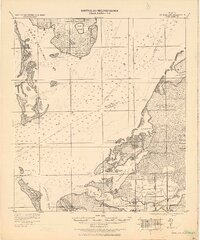
1921 Map of Fort De Soto
USGS Topo · Published 1921About this map
Fort De Soto stands as a strategic sentinel on Mullet Key, anchoring the entrance to Tampa Bay during a time when the coast was defined by maritime quarantine and early rail expansion. This 1921 reconnaissance documents the transitional landscape of the Florida coast, where the Seaboard Air Line railroad connects established settlements like Bradentown, Palmetto, and Ellenton. The map reveals the intricate water network of Boca Ciega Bay and Terraceia Bay, alongside specific federal infrastructure like the U.S. Quarantine Station. The inland areas around Gillette and Gulf City are dominated by salt marshes and bays, reflecting the region's topography before the extensive 20th-century coastal developments. Notable landmarks such as the Indian Hill Beacon and the junction at Terra Ceia Jc. provide critical reference points for understanding the early transport and communication corridors of Hillsboro and Manatee counties.
Find a feature on this map
56 named features on this map. Tap any name to fly to it.
Don’t see what you’re looking for? This feature index may not catch every label — zoom into the map to look around manually.
Map Details
Editions of this 1921 Fort De Soto Map
2 editions found
Other maps of this area

1921 · Sand Key
USGS Topo · 1:62,500

1921 · Tampa
USGS Topo · 1:62,500

1921 · St Petersburg
USGS Topo · 1:62,500

1942 · Cockroach Bay
USGS Topo · 1:31,680

1943 · St Petersburg
USGS Topo · 1:31,680

1943 · Pass-A-Grille
USGS Topo · 1:31,680

1943 · Bay Pines
USGS Topo · 1:31,680

1943 · Port Tampa
USGS Topo · 1:31,680

1944 · Egmont Key
USGS Topo · 1:31,680

1944 · Anna Maria
USGS Topo · 1:31,680