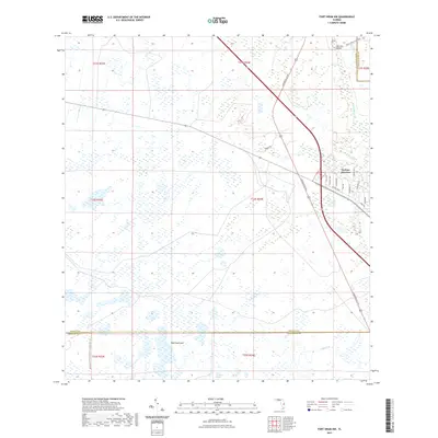
2021 Map of Fort Drum NW
USGS Topo · Published 2021About this map
Yeehaw Junction serves as the primary hub of this landscape, situated at the intersection of major transit corridors in southern Osceola County. The map details a transition from the structured street grid of the junction—featuring residential routes like Sunshine Ave and Tangerine Ln—to the expansive wetlands and marshes that dominate the surrounding territory. Much of the western portion is defined by the Kissimmee Prairie Preserve State Park Trl, illustrating the preservation of native Florida dry prairie. Significant hydrologic features such as Little Gumhead Marsh and Wolf Hammock indicate the natural drainage patterns of the region, while named crossings like Big Lolly Bridge and watercourses such as Cow Log Br and Padgett Br provide key landmarks for local navigation across the marshy terrain.
Find a feature on this map
30 named features on this map. Tap any name to fly to it.
Don’t see what you’re looking for? This feature index may not catch every label — zoom into the map to look around manually.
Map Details
Editions of this 2021 Fort Drum NW Map
This is the sole edition of this map. No revisions or reprints were ever made.
Other maps of this area

1953 · Fort Drum
USGS Topo · 1:24,000

1953 · Fort Kissimmee NE
USGS Topo · 1:24,000

1953 · Fort Drum SW
USGS Topo · 1:24,000

1953 · Lake Marian SE
USGS Topo · 1:24,000

1953 · Fort Drum NW
USGS Topo · 1:24,000

1953 · Kenansville SW
USGS Topo · 1:24,000

1953 · Fort Drum NE
USGS Topo · 1:24,000

1953 · Kenansville SE
USGS Topo · 1:24,000

1953 · Fort Kissimmee SE
USGS Topo · 1:24,000

1956 · Fort Pierce
USGS Topo · 1:250,000