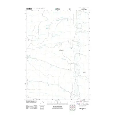
2011 Map of Fort Howes
USGS Topo · Published 2011About this map
Stag Rock Mountain and the prominent Stag Rock pillar overlook a landscape defined by an intricate network of ephemeral drainages and vital water sources in this part of Rosebud County. The map reveals a high concentration of named springs and small-scale water management projects, including Simon Reservoir, Coal Creek Reservoir, and the curiously named Doubtful Reservoir. These features, along with numerous numbered springs like Paget Spring Number One and Gate Creek Spring Number Two, trace the historical reliance on scattered water points for ranching and land use. Public access is centered at Cow Creek Campground, while the eastern portion is dominated by the winding course of Otter Creek and the notable Taylor Butte. This detailed inventory of springs and creek forks illustrates how water access dictated the naming and utility of the Montana high plains.
Find a feature on this map
44 named features on this map. Tap any name to fly to it.
Don’t see what you’re looking for? This feature index may not catch every label — zoom into the map to look around manually.
Map Details
Editions of this 2011 Fort Howes Map
This is the sole edition of this map. No revisions or reprints were ever made.
Other maps of this area

1954 · Hardin
USGS Topo · 1:250,000

1957 · Hardin
USGS Topo · 1:250,000

1958 · Hardin
USGS Topo · 1:250,000

1966 · Goodspeed Butte
USGS Topo · 1:24,000

1966 · Poker Jim Butte
USGS Topo · 1:24,000

1966 · Fort Howes
USGS Topo · 1:24,000

1966 · King Mountain
USGS Topo · 1:24,000
1966 · Green Creek
USGS Topo · 1:24,000
1967 · Yager Butte
USGS Topo · 1:24,000
1972 · Reanus Cone
USGS Topo · 1:24,000