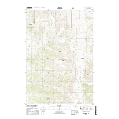
2017 Map of Fort Howes
USGS Topo · Published 2017About this map
Custer National Forest encompasses much of this landscape, where the high plains of southern Montana are carved by a network of drainage systems. The map centers on the border between Rosebud and Powder River counties, a region defined by complex hydrology and named springs. Ranching and land management are evident through the numerous water catchments like Simon Reservoir, Dunning Reservoir, and the skeptically named Doubtful Reservoir. Significant elevation markers include Stag Rock Mtn and Taylor Butte, which rise above the surrounding drainages of Otter Cr and Paget Cr. The settlement at Fort Howes serves as a primary reference point in this sparsely populated area, which remains dominated by open range and public forest land. Modern access is primarily facilitated via Otter Creek Rd, which follows the natural valley of the creek it names.
Find a feature on this map
54 named features on this map. Tap any name to fly to it.
Don’t see what you’re looking for? This feature index may not catch every label — zoom into the map to look around manually.
Map Details
Editions of this 2017 Fort Howes Map
This is the sole edition of this map. No revisions or reprints were ever made.
Other maps of this area

1954 · Hardin
USGS Topo · 1:250,000

1957 · Hardin
USGS Topo · 1:250,000

1958 · Hardin
USGS Topo · 1:250,000

1966 · Goodspeed Butte
USGS Topo · 1:24,000

1966 · Poker Jim Butte
USGS Topo · 1:24,000

1966 · Fort Howes
USGS Topo · 1:24,000

1966 · King Mountain
USGS Topo · 1:24,000
1966 · Green Creek
USGS Topo · 1:24,000
1967 · Yager Butte
USGS Topo · 1:24,000
1972 · Reanus Cone
USGS Topo · 1:24,000