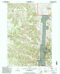
1995 Map of Fort Howes
USGS Topo · Published 1998About this map
Fort Howes (Historical Site) and the Fort Howes Work Center serve as focal points in this section of the Custer National Forest, where the landscape is defined by the drainage of Otter Creek and a network of isolated springs and reservoirs. This area, straddling the border of Rosebud and Powder River counties, reflects a managed wilderness where water management is critical for land use, evidenced by features like Doubtful Reservoir, Second Creek Reservoir, and Dunning Reservoir.
Find a feature on this map
45 named features on this map. Tap any name to fly to it.
Don’t see what you’re looking for? This feature index may not catch every label — zoom into the map to look around manually.
Map Details
Editions of this 1995 Fort Howes Map
This is the sole edition of this map. No revisions or reprints were ever made.
Other maps of this area

1954 · Hardin
USGS Topo · 1:250,000

1957 · Hardin
USGS Topo · 1:250,000

1958 · Hardin
USGS Topo · 1:250,000

1966 · Goodspeed Butte
USGS Topo · 1:24,000

1966 · Poker Jim Butte
USGS Topo · 1:24,000

1966 · Fort Howes
USGS Topo · 1:24,000

1966 · King Mountain
USGS Topo · 1:24,000
1966 · Green Creek
USGS Topo · 1:24,000
1967 · Yager Butte
USGS Topo · 1:24,000
1972 · Reanus Cone
USGS Topo · 1:24,000