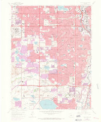
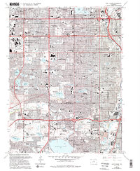
1965 Map of Fort Logan
USGS Topo · Published 1973About this map
Denver and its western suburbs undergo rapid post-war expansion in this mid-1960s survey, showing the intensification of residential and commercial development between the city center and the foothills. Significant land use is dedicated to federal and institutional footprints, most notably the massive Denver Federal Center and the Federal Correctional Institute near Harriman Lake. The landscape is also defined by a complex network of water management, with numerous reservoirs such as Marston Lake, Kendrick Reservoir, and Smith Res serving the growing population.
Find a feature on this map
151 named features on this map. Tap any name to fly to it.
Don’t see what you’re looking for? This feature index may not catch every label — zoom into the map to look around manually.
Map Details
Editions of this 1965 Fort Logan Map
5 editions found
Other maps of this area

1890 · East Denver
USGS Topo · 1:125,000

1899 · West Denver
USGS Topo · 1:125,000

1935 · East Denver Nos. 3 and 4
USGS Topo · 1:48,000

1938 · Morrison
USGS Topo · 1:24,000

1938 · Derby
USGS Topo · 1:24,000

1939 · Golden
USGS Topo · 1:24,000

1940 · Englewood
USGS Topo · 1:31,680

1940 · Derby
USGS Topo · 1:31,680

1941 · Arvada
USGS Topo · 1:31,680

1941 · Fort Logan
USGS Topo · 1:31,680