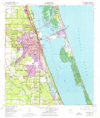
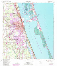
1949 Map of Fort Pierce
USGS Topo · Published 1976About this map
Fort Pierce and the surrounding coastal landscape are documented here during a period of transition, showing the infrastructure of the mid-20th century alongside newer 1970s suburban expansions. The Florida East Coast railroad serves as the primary inland spine, connecting the northern settlement of St Lucie through the central urban core to White City in the south. The map captures a complex waterfront economy, featuring the Municipal Yacht Basin and a US Coast Guard station guarding the Ft Pierce Inlet. To the east, the barrier of Hutchinson Island separates the Indian River from the Atlantic Ocean, marked by natural features like Bear Point and Jack Island. Inland development is anchored by St Lucie County Airport and recreational sites like the Botanical Gardens, while the North Fork St Lucie River and Tenmile Creek drain the western agricultural and residential lands.
Find a feature on this map
55 named features on this map. Tap any name to fly to it.
Don’t see what you’re looking for? This feature index may not catch every label — zoom into the map to look around manually.
Map Details
Editions of this 1949 Fort Pierce Map
6 editions found
Other maps of this area

1948 · Ankona
USGS Topo · 1:24,000

1948 · Eden
USGS Topo · 1:24,000

1948 · Indrio
USGS Topo · 1:24,000

1949 · Fort Pierce
USGS Topo · 1:24,000

1949 · Oslo
USGS Topo · 1:24,000

1949 · Fort Pierce NW
USGS Topo · 1:24,000

1950 · Ankona
USGS Topo · 1:24,000

1950 · Fort Pierce
USGS Topo · 1:24,000

1950 · Fort Pierce NW
USGS Topo · 1:24,000

1950 · Oslo
USGS Topo · 1:24,000