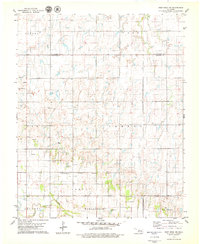
1979 Map of Fort Reno NE
USGS Topo · Published 1979About this map
The North Canadian River winds through the southern reaches of this landscape, anchoring a region defined by agricultural field lines and small rural hubs. To the north of the river, Darlington and the corporate boundary of Calumet mark the transition from river valley to the higher plains. Local landmarks such as The Mound and a nearby Landing Field provide orientation in this open terrain, which was mapped by the Geological Survey using aerial photography from the mid-1970s.
Find a feature on this map
14 named features on this map. Tap any name to fly to it.
Don’t see what you’re looking for? This feature index may not catch every label — zoom into the map to look around manually.
Map Details
Editions of this 1979 Fort Reno NE Map
This is the sole edition of this map. No revisions or reprints were ever made.
Other maps of this area

1892 · Kingfisher
USGS Topo · 1:125,000

1893 · Fort Reno
USGS Topo · 1:62,500

1893 · Loyal
USGS Topo · 1:62,500

1895 · Kingfisher
USGS Topo · 1:125,000

1941 · Fort Reno
USGS Topo · 1:62,500

1942 · Fort Reno
USGS Topo · 1:62,500

1949 · Fort Reno
USGS Topo · 1:62,500

1954 · Oklahoma City
USGS Topo · 1:250,000

1955 · Clinton
USGS Topo · 1:250,000

1957 · Clinton
USGS Topo · 1:250,000