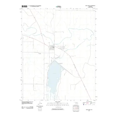
2010 Map of Fort Supply
USGS Topo · Published 2010About this map
Fort Supply sits at the vital confluence where the Beaver River and Wolf Creek meet in Woodward County. The landscape is dominated by the extensive Fort Supply Reservoir, which is contained by the Fort Supply Dam on the southern edge of the settlement. This 2010 survey details the local road network, including family-history landmarks such as Fairlawn Cemetery accessed via Fairlawn Cemetary Rd. The map illustrates a contemporary view of this plains community, showing the intersection of water management and rural settlement patterns. Researchers can trace the modern boundaries of the reservoir against the original creek beds that still wind through the northern sections of the quadrangle.
Find a feature on this map
20 named features on this map. Tap any name to fly to it.
Don’t see what you’re looking for? This feature index may not catch every label — zoom into the map to look around manually.
Map Details
Editions of this 2010 Fort Supply Map
This is the sole edition of this map. No revisions or reprints were ever made.
Other maps of this area

1955 · Woodward
USGS Topo · 1:250,000

1958 · Woodward
USGS Topo · 1:250,000

1969 · Fargo
USGS Topo · 1:24,000

1969 · Fargo NW
USGS Topo · 1:24,000

1969 · Woodward
USGS Topo · 1:24,000

1970 · Sleeping Bear Creek SW
USGS Topo · 1:24,000

1970 · Sleeping Bear Creek NW
USGS Topo · 1:24,000

1971 · May East
USGS Topo · 1:24,000

1971 · Fort Supply
USGS Topo · 1:24,000

1971 · Fort Supply NW
USGS Topo · 1:24,000