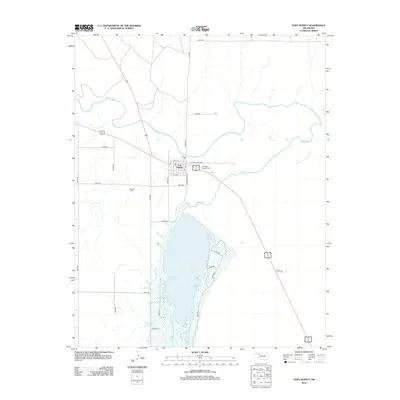
2012 Map of Fort Supply
USGS Topo · Published 2012About this map
Fort Supply anchors this Western Oklahoma landscape at the confluence where the Beaver River meets Wolf Cr. The town plan is defined by a distinct grid including William S Key Blvd and Reservation Ave, reflecting the area's transition from a frontier military post to a modern community. To the south, the expansive Fort Supply Reservoir dominates the terrain, with its shoreline accessed by a network of rural routes such as e0320 RD and e0340 RD. Genealogists and local historians will find significant value in the marked locations of Fairlawn Cem west of town and the Ft Supply Hospital Cem situated near the local medical complex. The map reveals the critical relationship between the water resources of the river basin and the development of the high plains, showing how transportation corridors like the modern highway system bypass the water's edge to connect the region's scattered agricultural and institutional hubs.
Find a feature on this map
29 named features on this map. Tap any name to fly to it.
Don’t see what you’re looking for? This feature index may not catch every label — zoom into the map to look around manually.
Map Details
Editions of this 2012 Fort Supply Map
This is the sole edition of this map. No revisions or reprints were ever made.
Other maps of this area

1955 · Woodward
USGS Topo · 1:250,000

1958 · Woodward
USGS Topo · 1:250,000

1969 · Fargo
USGS Topo · 1:24,000

1969 · Fargo NW
USGS Topo · 1:24,000

1969 · Woodward
USGS Topo · 1:24,000

1970 · Sleeping Bear Creek SW
USGS Topo · 1:24,000

1970 · Sleeping Bear Creek NW
USGS Topo · 1:24,000

1971 · May East
USGS Topo · 1:24,000

1971 · Fort Supply
USGS Topo · 1:24,000

1971 · Fort Supply NW
USGS Topo · 1:24,000