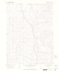
1969 Map of Fortification
USGS Topo · Published 1972About this map
Fortification Rocks dominate the southern landscape of this 1969 Moffat County survey, a region defined by high-elevation ranching and remote infrastructure. The drainage system of Fortification Creek and its tributaries, including Fourmile Creek and Mud Draw, carves through the terrain, while early aviation and energy development are evidenced by a Landing Strip and a long-distance Pipeline cutting across the northwestern quadrants.
Find a feature on this map
13 named features on this map. Tap any name to fly to it.
Don’t see what you’re looking for? This feature index may not catch every label — zoom into the map to look around manually.
Map Details
Editions of this 1969 Fortification Map
3 editions found
Other maps of this area

1916 · Craig
USGS Topo · 1:125,000

1923 · Elkhead Creek
USGS Topo · 1:62,500

1924 · Elkhead Creek
USGS Topo · 1:62,500

1954 · Craig
USGS Topo · 1:250,000

1957 · Craig
USGS Topo · 1:250,000

1958 · Craig
USGS Topo · 1:250,000

1960 · Craig
USGS Topo · 1:250,000

1962 · Craig
USGS Topo · 1:250,000

1964 · Craig
USGS Topo · 1:250,000

1965 · Craig
USGS Topo · 1:250,000