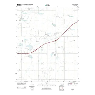
2010 Map of Foss
USGS Topo · Published 2010About this map
Foss serves as the primary hub of this western Oklahoma landscape, situated at a major transportation intersection. The surrounding terrain is defined by a dense network of water management features, including numerous reservoirs and dams managed by the Turkey Creek and Soldier Creek watershed projects. Large bodies of water like Clinton Lake and the Ronald Sewell Reservoir dominate the hydrology, while smaller catchments like Turkey Creek Site 3 Reservoir dot the rural sections. For genealogists and local historians, the map preserves the locations of several burial grounds, including Old Foss Cemetery, Kerns Cemetery, Saint Francis Cemetery, and Page Cemetery. These sites are spread across the sections, often located near local watercourses such as Sand Creek or Oak Creek, providing a clear view of the area's organized rural layout and community focal points during the early 21st century.
Find a feature on this map
54 named features on this map. Tap any name to fly to it.
Don’t see what you’re looking for? This feature index may not catch every label — zoom into the map to look around manually.
Map Details
Editions of this 2010 Foss Map
This is the sole edition of this map. No revisions or reprints were ever made.
Other maps of this area

1955 · Clinton
USGS Topo · 1:250,000

1957 · Clinton
USGS Topo · 1:250,000

1957 · Butler
USGS Topo · 1:62,500

1957 · Dill City
USGS Topo · 1:62,500

1960 · Hammon
USGS Topo · 1:62,500

1961 · Elk City
USGS Topo · 1:62,500

1976 · Butler SW
USGS Topo · 1:24,000

1976 · Dill City NE
USGS Topo · 1:24,000

1976 · Dill City SE
USGS Topo · 1:24,000
1976 · Butler SE
USGS Topo · 1:24,000