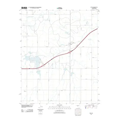
2012 Map of Foss
USGS Topo · Published 2012About this map
Foss serves as the central hub for this portion of Washita County, situated where state routes intersect an increasingly structured rural grid. The town is flanked by its history, seen in the distinct locations of the Old Foss Cem and the New Foss Cem nearby. The landscape is defined by a dense network of water management projects, including numerous Turkey Creek and Soldier Creek watershed reservoirs that dot the prairies. To the southwest, Clinton Lake is a prominent water feature fed by Turkey Cr, while other seasonal drainages like Monument Cr and Sand Cr carve paths through the section lines. This 2012 survey illustrates the modern agricultural and hydraulic character of the region, where family-named sites like Ronald Sewell Reservoir and established burial grounds such as Kerns Cem and Saint Francis Cem anchor the community's local geography.
Find a feature on this map
43 named features on this map. Tap any name to fly to it.
Don’t see what you’re looking for? This feature index may not catch every label — zoom into the map to look around manually.
Map Details
Editions of this 2012 Foss Map
This is the sole edition of this map. No revisions or reprints were ever made.
Other maps of this area

1955 · Clinton
USGS Topo · 1:250,000

1957 · Clinton
USGS Topo · 1:250,000

1957 · Butler
USGS Topo · 1:62,500

1957 · Dill City
USGS Topo · 1:62,500

1960 · Hammon
USGS Topo · 1:62,500

1961 · Elk City
USGS Topo · 1:62,500

1976 · Butler SW
USGS Topo · 1:24,000

1976 · Dill City NE
USGS Topo · 1:24,000

1976 · Dill City SE
USGS Topo · 1:24,000
1976 · Butler SE
USGS Topo · 1:24,000