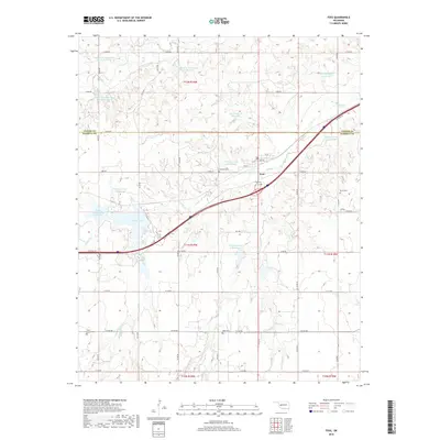
2018 Map of Foss
USGS Topo · Published 2018About this map
The town of Foss sits along the Turkey Cr drainage in western Oklahoma, serving as a focal point for the surrounding agricultural landscape of Washita and Custer counties. This modern survey illustrates a complex water management system composed of numerous watershed sites and reservoirs, including the Turkey Creek Site 6 Reservoir, Ronald Sewell Reservoir, and the significant waters of Clinton Lake. These features reflect the long-term conservation efforts typical of the Great Plains, where managed water bodies sustain the local ranching and farming economy. For those tracing local history or family heritage, the map identifies several distinct burial grounds such as Old Foss Cem, Kerns Cem, and Saint Francis Cem. The infrastructure follows a rigid section-line road grid, from e1050 RD to e1130 RD, providing a precise reference for locating historical property boundaries and rural homesteads.
Find a feature on this map
42 named features on this map. Tap any name to fly to it.
Don’t see what you’re looking for? This feature index may not catch every label — zoom into the map to look around manually.
Map Details
Editions of this 2018 Foss Map
This is the sole edition of this map. No revisions or reprints were ever made.
Other maps of this area

1955 · Clinton
USGS Topo · 1:250,000

1957 · Clinton
USGS Topo · 1:250,000

1957 · Butler
USGS Topo · 1:62,500

1957 · Dill City
USGS Topo · 1:62,500

1960 · Hammon
USGS Topo · 1:62,500

1961 · Elk City
USGS Topo · 1:62,500

1976 · Butler SW
USGS Topo · 1:24,000

1976 · Dill City NE
USGS Topo · 1:24,000

1976 · Dill City SE
USGS Topo · 1:24,000
1976 · Butler SE
USGS Topo · 1:24,000