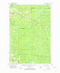
1956 Map of Foster City
USGS Topo · Published 1979About this map
The Chicago and North Western railroad corridor shapes the northern landscape of this mid-century survey, threading through the timber-rich lands of the Sturgeon River State Forest and Menominee State Forest. Small settlements such as Foster City, Hardwood, and Helps serve as focal points for the region's logging and transit network. To the south, the village of Waucedah lies near the Township Cem, while the neighboring settlement of Hamilton is situated along Cheney Cr.
Find a feature on this map
44 named features on this map. Tap any name to fly to it.
Don’t see what you’re looking for? This feature index may not catch every label — zoom into the map to look around manually.
Map Details
Editions of this 1956 Foster City Map
3 editions found
Other maps of this area

1932 · Helena SW
USGS Topo · 1:31,680

1939 · Pembine
USGS Topo · 1:48,000

1947 · Pembine
USGS Topo · 1:48,000

1951 · Helena SW
USGS Topo · 1:31,680

1954 · Escanaba
USGS Topo · 1:250,000

1955 · Vulcan
USGS Topo · 1:24,000

1955 · Norway
USGS Topo · 1:62,500

1955 · Ralph
USGS Topo · 1:62,500

1956 · Foster City
USGS Topo · 1:62,500

1957 · Escanaba
USGS Topo · 1:250,000