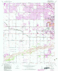
1952 Map of Fowler
USGS Topo · Published 1983About this map
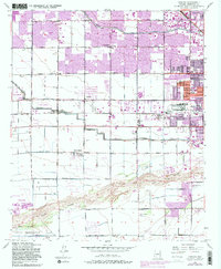
Alhambra and the western reaches of Phoenix dominate the northeastern portion of this survey, reflecting the rapid expansion of the metropolitan area toward Tolleson. The landscape transitions from dense residential blocks and parks like Encanto Park and Starlight Park into a systematic grid of agricultural fields and irrigation infrastructure. The Grand Canal and the Gila and Salt River Base Line provide the primary structural framework for the region's development, while the dry bed of the Salt River cuts across the southern portion. This area is characterized by essential county infrastructure and community landmarks, including the County Hospital, County Juvenile Home, and the Beth Israel Cem. These institutional clusters and early school sites like Murphy Sch No 2 and Riverside Sch offer a clear record of how public services and education kept pace with the region's mid-century growth.
Find a feature on this map
44 named features on this map. Tap any name to fly to it.
Don’t see what you’re looking for? This feature index may not catch every label — zoom into the map to look around manually.
Map Details
Editions of this 1952 Fowler Map
6 editions found
Other maps of this area

1912 · Phoenix
USGS Topo · 1:62,500

1914 · Phoenix
USGS Topo · 1:62,500

1946 · Avondale
USGS Topo · 1:62,500

1948 · Cashion
USGS Topo · 1:62,500

1952 · Lone Butte
USGS Topo · 1:24,000

1952 · Laveen
USGS Topo · 1:24,000

1952 · Phoenix
USGS Topo · 1:24,000

1952 · Fowler
USGS Topo · 1:24,000

1952 · Phoenix
USGS Topo · 1:62,500

1954 · Phoenix
USGS Topo · 1:250,000