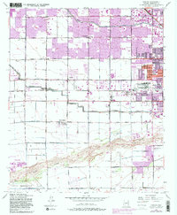
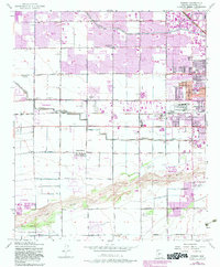
1952 Map of Fowler
USGS Topo · Published 1983About this map
Phoenix expanded westward into agricultural lands during the mid-twentieth century, as documented in this 1951-1952 survey with later revisions. The landscape is defined by a rigid grid of irrigation and transport, featuring the Grand Canal and Roosevelt Canal which sustained the desert valley. Smaller settlements like Fowler and Santa Maria sit amidst a network of schools such as Coe Sch and Starlight Park Sch. Industrial and institutional footprints are prominent, including a large Aluminum Plant and the County Juvenile Home Hospital.
Find a feature on this map
38 named features on this map. Tap any name to fly to it.
Don’t see what you’re looking for? This feature index may not catch every label — zoom into the map to look around manually.
Map Details
Editions of this 1952 Fowler Map
6 editions found
Other maps of this area

1912 · Phoenix
USGS Topo · 1:62,500

1914 · Phoenix
USGS Topo · 1:62,500

1946 · Avondale
USGS Topo · 1:62,500

1948 · Cashion
USGS Topo · 1:62,500

1952 · Lone Butte
USGS Topo · 1:24,000

1952 · Laveen
USGS Topo · 1:24,000

1952 · Phoenix
USGS Topo · 1:24,000

1952 · Fowler
USGS Topo · 1:24,000

1952 · Phoenix
USGS Topo · 1:62,500

1954 · Phoenix
USGS Topo · 1:250,000