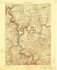
1908 Map of Foxburg
USGS Topo · Published 1923About this map
The Allegheny River carves a deep, winding course through this Western Pennsylvania landscape, serving as the primary corridor for the Pennsylvania RR and several industrial settlements. The confluence with the Clarion River at Foxburg marks a significant junction of water and rail, including the Baltimore and Ohio RR. The surrounding hillsides are dotted with evidence of early 20th-century industry and community life, from the Canoe Furnace near Edenburg Knox PO to active extraction sites like the Eagle Mine and Blue Goose Mine further south.
Find a feature on this map
76 named features on this map. Tap any name to fly to it.
Don’t see what you’re looking for? This feature index may not catch every label — zoom into the map to look around manually.
Map Details
Editions of this 1908 Foxburg Map
5 editions found
Other maps of this area

1900 · Kittanning
USGS Topo · 1:62,500

1901 · Rural Valley
USGS Topo · 1:62,500

1902 · Kittanning
USGS Topo · 1:62,500

1903 · Rural Valley
USGS Topo · 1:62,500

1906 · Clarion
USGS Topo · 1:62,500

1907 · Clarion
USGS Topo · 1:62,500

1907 · Foxburg
USGS Topo · 1:62,500

1908 · Foxburg
USGS Topo · 1:62,500

1909 · Franklin
USGS Topo · 1:62,500

1909 · Butler
USGS Topo · 1:62,500