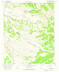
1964 Map of Foxen Canyon
USGS Topo · Published 1965About this map
Large ranches and early California heritage define this 1964 survey of the central Santa Barbara backcountry. The landscape is dominated by the Sisquoc River valley and the steep ridges of the San Rafael Mountains. Historical memory is preserved at the Foxen Adobe (Site) and the nearby Fremont-Foxen Monument, marking the pivotal role this canyon played in the state's transition to American control.
Find a feature on this map
48 named features on this map. Tap any name to fly to it.
Don’t see what you’re looking for? This feature index may not catch every label — zoom into the map to look around manually.
Map Details
Editions of this 1964 Foxen Canyon Map
2 editions found
Other maps of this area

1905 · Lompoc
USGS Topo · 1:125,000

1942 · Lompoc
USGS Topo · 1:125,000

1942 · Lompoc
USGS Topo · 1:62,500

1942 · Santa Maria
USGS Topo · 1:62,500

1942 · Tepusquet Peak
USGS Topo · 1:62,500

1942 · Los Olivos
USGS Topo · 1:62,500

1943 · Los Olivos
USGS Topo · 1:62,500

1943 · Tepusquet Peak
USGS Topo · 1:62,500

1943 · Lompoc
USGS Topo · 1:125,000

1947 · Careaga Canyon
USGS Topo · 1:24,000