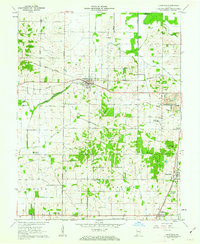
1961 Map of Francisco
USGS Topo · Published 1963About this map
The town of Francisco sits at the crossing of the Southern railroad and several regional roads, serving as a central hub in Gibson County during the early 1960s. The landscape is defined by its agrarian roots and the slow encroachment of industrial activity, most notably seen at the Strip Mine near the southern edge. The area is heavily intersected by infrastructure, featuring numerous pipelines and the legacy of earlier transportation routes like the Old Railroad Grade and the Southern Railroad Grade.
Find a feature on this map
36 named features on this map. Tap any name to fly to it.
Don’t see what you’re looking for? This feature index may not catch every label — zoom into the map to look around manually.
Map Details
Editions of this 1961 Francisco Map
3 editions found
Other maps of this area

1901 · Princeton
USGS Topo · 1:62,500

1901 · Haubstadt
USGS Topo · 1:62,500

1902 · Ditney
USGS Topo · 1:125,000

1902 · Boonville
USGS Topo · 1:62,500

1903 · Haubstadt
USGS Topo · 1:62,500

1903 · Petersburg
USGS Topo · 1:62,500

1903 · Princeton
USGS Topo · 1:62,500

1903 · Patoka
USGS Topo · 1:125,000

1956 · Vincennes
USGS Topo · 1:250,000

1957 · Vincennes
USGS Topo · 1:250,000