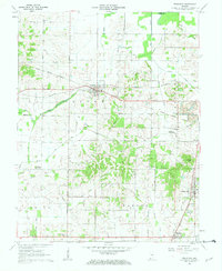
1961 Map of Francisco
USGS Topo · Published 1963About this map
Francisco serves as a central hub in Gibson County, where the Southern Railroad intersects with a landscape shaped by both pioneer transit and industrial expansion. The map clearly delineates the Erie and Wabash Canal as it cuts through the northern sections, paralleling the legacy of the Old Indian Treaty Boundary which bisects the townships of Center and Columbia. This era reflects a transition toward heavy resource extraction, evidenced by the presence of Coalmine Number Two and various Strip Mine operations near Somerville.
Find a feature on this map
44 named features on this map. Tap any name to fly to it.
Don’t see what you’re looking for? This feature index may not catch every label — zoom into the map to look around manually.
Map Details
Editions of this 1961 Francisco Map
3 editions found
Other maps of this area

1901 · Princeton
USGS Topo · 1:62,500

1901 · Haubstadt
USGS Topo · 1:62,500

1902 · Ditney
USGS Topo · 1:125,000

1902 · Boonville
USGS Topo · 1:62,500

1903 · Haubstadt
USGS Topo · 1:62,500

1903 · Petersburg
USGS Topo · 1:62,500

1903 · Princeton
USGS Topo · 1:62,500

1903 · Patoka
USGS Topo · 1:125,000

1956 · Vincennes
USGS Topo · 1:250,000

1957 · Vincennes
USGS Topo · 1:250,000