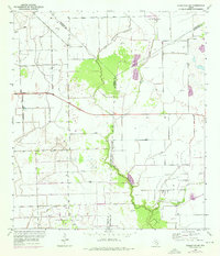
1952 Map of Francitas NE
USGS Topo · Published 1976About this map
Petroleum extraction and agriculture define the landscape of the Texas Gulf Coast as it transitioned into the mid-century. This region, where Jackson and Matagorda Counties meet, is crisscrossed by an extensive network of Levee systems designed to manage the low-lying terrain. The coastal prairie is dominated by significant energy infrastructure, including the North Francitas Oil Field, Little Kentucky Field, and Midfield Field.
Find a feature on this map
13 named features on this map. Tap any name to fly to it.
Don’t see what you’re looking for? This feature index may not catch every label — zoom into the map to look around manually.
Map Details
Editions of this 1952 Francitas NE Map
2 editions found
Other maps of this area

1951 · Danevang
USGS Topo · 1:24,000

1952 · Francitas NW
USGS Topo · 1:24,000

1952 · Francitas
USGS Topo · 1:24,000

1952 · Blessing
USGS Topo · 1:24,000

1952 · Francitas NE
USGS Topo · 1:24,000

1952 · Midfield
USGS Topo · 1:24,000

1952 · La Ward
USGS Topo · 1:24,000

1953 · Beeville
USGS Topo · 1:250,000

1953 · Seguin
USGS Topo · 1:250,000

1956 · Beeville
USGS Topo · 1:250,000