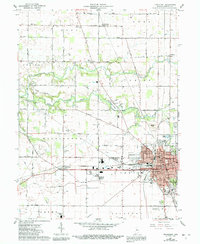
1961 Map of Frankfort
USGS Topo · Published 1991About this map
Frankfort serves as the bustling centerpiece of this Clinton County landscape, where the Norfolk and Western rail lines converge near the downtown grid. The map reveals a community well-established by the mid-20th century, featuring landmarks like the County Hospital, County Fairgrounds, and several local schools including Kyger Sch and Lincoln Sch. Beyond the city limits, the rural character of the surrounding townships is defined by a network of drainage ditches like Boyles Ditch and the winding course of South Fork Wildcat Creek. Small clusters of activity persist at Jefferson and Cambria, while numerous family cemeteries such as Bunnell Cem and Bennett Cem are scattered across the agrarian landscape. The presence of Camp Walter S Fowler and the Frankfort Municipal Airport highlights the area's diverse land use, from military recreation to regional aviation infrastructure.
Find a feature on this map
52 named features on this map. Tap any name to fly to it.
Don’t see what you’re looking for? This feature index may not catch every label — zoom into the map to look around manually.
Map Details
Editions of this 1961 Frankfort Map
3 editions found
Other maps of this area

1953 · Danville
USGS Topo · 1:250,000

1955 · Danville
USGS Topo · 1:250,000

1956 · Danville
USGS Topo · 1:250,000

1961 · Michigantown
USGS Topo · 1:24,000

1961 · Mulberry
USGS Topo · 1:24,000

1961 · Pyrmont
USGS Topo · 1:24,000

1961 · Mechanicsburg
USGS Topo · 1:24,000

1961 · Rossville
USGS Topo · 1:24,000

1961 · Burlington
USGS Topo · 1:24,000

1961 · Frankfort
USGS Topo · 1:24,000