
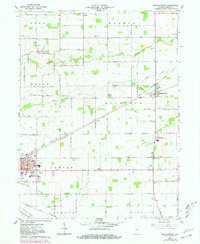
1961 Map of Michigantown
USGS Topo · Published 1962About this map
The rural landscape of Clinton County is defined by a rigid grid of agricultural roads and the intersection of vital transport lines. In the eastern portion of the sheet, Michigantown serves as a local hub, while the eastern edge of Frankfort dominates the southwest, featuring residential developments like Kentwood and Wilshire. The New York Chicago and St Louis Railroad cuts diagonally across the township, passing through Avery and Boylestown, while the Monon Railroad skirts the southern boundary. This era of settlement is preserved in numerous family and community burial grounds, such as Old Whiteman Cem and Layton Cem. The presence of the Clinton Central High School and a Drive-in Theater reflects the mid-century consolidation of social and educational infrastructure amid a landscape drained by the South Fork Wildcat Creek and Kilmore Creek.
Find a feature on this map
53 named features on this map. Tap any name to fly to it.
Don’t see what you’re looking for? This feature index may not catch every label — zoom into the map to look around manually.
Map Details
Editions of this 1961 Michigantown Map
2 editions found
Other maps of this area

1953 · Danville
USGS Topo · 1:250,000

1955 · Danville
USGS Topo · 1:250,000

1956 · Danville
USGS Topo · 1:250,000

1961 · Russiaville
USGS Topo · 1:24,000

1961 · Mechanicsburg
USGS Topo · 1:24,000

1961 · Hillisburg
USGS Topo · 1:24,000

1961 · Rossville
USGS Topo · 1:24,000

1961 · Burlington
USGS Topo · 1:24,000

1961 · Frankfort
USGS Topo · 1:24,000
1961 · Kirklin
USGS Topo · 1:24,000