
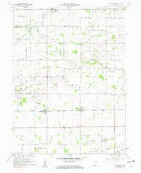
1961 Map of Hillisburg
USGS Topo · Published 1962About this map
The New York Chicago and St Louis railroad serves as the central artery for this mid-century agricultural landscape, connecting the small settlements of Forest, Hillisburg, and Scircleville. These villages are surrounded by a dense network of drainage canals and natural waterways, including the South Fork Wildcat Creek, Sugar Creek, and Kilmore Creek, reflecting the intensive water management required for farming in the Indiana till plains. For family historians, the sheet is exceptionally rich in genealogical landmarks, with numerous family and community burial sites such as Prairie Chapel Cem, Bacon Cem, and Scott Cem scattered across Warren, Johnson, and Michigan townships. The presence of Kings Corner and localized landmarks like the Storage Bins near Scircleville illustrate the localized economy of grain storage and transport that defined the region during this era.
Find a feature on this map
38 named features on this map. Tap any name to fly to it.
Don’t see what you’re looking for? This feature index may not catch every label — zoom into the map to look around manually.
Map Details
Editions of this 1961 Hillisburg Map
2 editions found
Other maps of this area

1953 · Danville
USGS Topo · 1:250,000

1955 · Danville
USGS Topo · 1:250,000

1956 · Danville
USGS Topo · 1:250,000

1960 · Kokomo West
USGS Topo · 1:24,000

1960 · Kempton
USGS Topo · 1:24,000

1961 · Michigantown
USGS Topo · 1:24,000

1961 · Russiaville
USGS Topo · 1:24,000

1961 · Sheridan
USGS Topo · 1:24,000

1961 · Mechanicsburg
USGS Topo · 1:24,000

1961 · Burlington
USGS Topo · 1:24,000