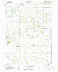
1961 Map of Hillisburg
USGS Topo · Published 1977About this map
Agricultural patterns and small-town commerce define this Clinton County landscape as it appeared in the early 1960s. The New York Chicago and St Louis Railroad serves as a primary east-west corridor, connecting the settlements of Hillisburg, Scircleville, and Forest. These communities are situated within a surveyor's grid of section roads like 400 North Road and 200 South Road, where grain storage and local transit were central to the rural economy.
Find a feature on this map
48 named features on this map. Tap any name to fly to it.
Don’t see what you’re looking for? This feature index may not catch every label — zoom into the map to look around manually.
Map Details
Editions of this 1961 Hillisburg Map
2 editions found
Other maps of this area

1953 · Danville
USGS Topo · 1:250,000

1955 · Danville
USGS Topo · 1:250,000

1956 · Danville
USGS Topo · 1:250,000

1960 · Kokomo West
USGS Topo · 1:24,000

1960 · Kempton
USGS Topo · 1:24,000

1961 · Michigantown
USGS Topo · 1:24,000

1961 · Russiaville
USGS Topo · 1:24,000

1961 · Sheridan
USGS Topo · 1:24,000

1961 · Mechanicsburg
USGS Topo · 1:24,000

1961 · Hillisburg
USGS Topo · 1:24,000