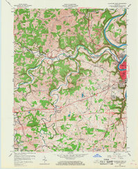
1959 Map of Frankfort West
USGS Topo · Published 1967About this map
Frankfort and its western outskirts are anchored by the winding course of the Kentucky River and the rhythmic path of the Louisville and Nashville railroad. The landscape is deeply carved by water, with Benson Creek and South Benson Creek dictating the placement of early infrastructure like the Midland Trail and Old Harrodsburg Road. In this era, new residential expansions like Thistleton Heights and Cloverdale contrast with established rural hamlets such as Bridgeport and Evergreen. Local history is preserved in the numerous country churches and family landmarks, including Mt Zion Ch and the Sudduth Cem. The map captures a moment of mid-century modernization, evidenced by the development of the Capital City Airport and sections of road marked Under Construction, illustrating the transition of the Kentucky state capital as it reached beyond its river-bound core into the surrounding limestone hills.
Find a feature on this map
55 named features on this map. Tap any name to fly to it.
Don’t see what you’re looking for? This feature index may not catch every label — zoom into the map to look around manually.
Map Details
Editions of this 1959 Frankfort West Map
2 editions found
Other maps of this area

1906 · Lockport
USGS Topo · 1:48,000

1908 · Lockport
USGS Topo · 1:62,500

1922 · Frankfort
USGS Topo · 1:48,000

1923 · Waddy
USGS Topo · 1:48,000

1924 · Frankfort
USGS Topo · 1:62,500

1925 · Mount Eden
USGS Topo · 1:48,000

1927 · Mount Eden
USGS Topo · 1:62,500

1928 · New Castle
USGS Topo · 1:48,000

1932 · New Castle
USGS Topo · 1:62,500

1951 · Lawrenceburg
USGS Topo · 1:24,000