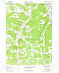
1968 Map of Franklin Forks
USGS Topo · Published 1978About this map
The Snake Creek valley anchors this 1960s study of Susquehanna County, Pennsylvania, showing a landscape defined by small rural hamlets and an extensive extractive industry. While the Susquehanna River and Conrail rail line cut through the northeastern corner near Hallstead, the interior is a network of township roads connecting historic settlements like Lawsville Center and Franklin Forks. The high frequency of labeled quarries and gravel pits throughout the hillsides, such as those near Stonecrop Hill and Franklin Hill, points to the region's historical reliance on stone and aggregate production.
Find a feature on this map
41 named features on this map. Tap any name to fly to it.
Don’t see what you’re looking for? This feature index may not catch every label — zoom into the map to look around manually.
Map Details
Editions of this 1968 Franklin Forks Map
Other maps of this area

1904 · Binghamton
USGS Topo · 1:62,500

1905 · Nineveh
USGS Topo · 1:62,500

1932 · Susquehanna
USGS Topo · 1:62,500

1935 · Binghamton West
USGS Topo · 1:24,000

1935 · Susquehanna
USGS Topo · 1:62,500

1937 · Binghamton East
USGS Topo · 1:24,000

1942 · Binghamton West
USGS Topo · 1:31,680

1942 · Binghamton East
USGS Topo · 1:31,680

1943 · Montrose
USGS Topo · 1:62,500

1945 · Montrose
USGS Topo · 1:62,500