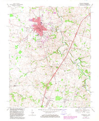
1968 Map of Franklin
USGS Topo · Published 1983About this map
Franklin serves as the focal point of this survey, shown during a period of urban expansion that extended the city limits toward the Louisville and Nashville railroad tracks. The landscape is defined by the winding course of the West Fork Drakes Creek, which draws a complex path through the limestone-rich terrain of Simpson County and across the state line. Evidence of early industry and community life is scattered along these waterways, most notably at the Peden Mill site and the nearby Peden Mill Cem.
Find a feature on this map
70 named features on this map. Tap any name to fly to it.
Don’t see what you’re looking for? This feature index may not catch every label — zoom into the map to look around manually.
Map Details
Editions of this 1968 Franklin Map
4 editions found
Other maps of this area

1921 · Bowling Green
USGS Topo · 1:62,500

1923 · Bowling Green
USGS Topo · 1:62,500

1928 · Adolphus
USGS Topo · 1:48,000

1931 · Adolphus
USGS Topo · 1:62,500

1942 · Gallatin
USGS Topo · 1:100,000

1951 · Woodburn
USGS Topo · 1:24,000

1951 · Franklin
USGS Topo · 1:24,000

1951 · Prices Mill
USGS Topo · 1:24,000

1951 · Auburn
USGS Topo · 1:24,000

1953 · Orlinda
USGS Topo · 1:24,000