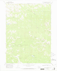
1969 Map of Freeman Reservoir
USGS Topo · Published 1973About this map
Routt National Forest dominates this high-country landscape within the Elkhead Mountains, where the 1968 aerial survey captures a terrain defined by steep drainages and isolated peaks. Water management for the high plateau is evident at Freeman Reservoir and Martin Cull Reservoir, which serve as focal points for the surrounding hydrology. The map details a network of primitive access routes, specifically labeled as Jeep Trails and (Pack) Trails, that navigate the ridges between Mount Welba and Mount Oliphant.
Find a feature on this map
21 named features on this map. Tap any name to fly to it.
Don’t see what you’re looking for? This feature index may not catch every label — zoom into the map to look around manually.
Map Details
Editions of this 1969 Freeman Reservoir Map
2 editions found
Other maps of this area

1916 · Craig
USGS Topo · 1:125,000

1923 · Elkhead Creek
USGS Topo · 1:62,500

1924 · Elkhead Creek
USGS Topo · 1:62,500

1954 · Craig
USGS Topo · 1:250,000

1957 · Craig
USGS Topo · 1:250,000

1958 · Craig
USGS Topo · 1:250,000

1960 · Craig
USGS Topo · 1:250,000

1962 · Craig
USGS Topo · 1:250,000

1964 · Craig
USGS Topo · 1:250,000

1965 · Craig
USGS Topo · 1:250,000