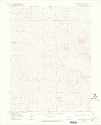
1969 Map of Freeman Reservoir
USGS Topo · Published 1973About this map
The Elkhead Mountains dominate this high-altitude landscape within the Routt National Forest, where drainage systems like Fourmile Creek and Willow Creek carve through the terrain. The map details a remote wilderness area defined by significant peaks, including Mount Weiba, Mount Oliphant, and Black Mountain. Human presence is minimal, marked primarily by a network of trails and jeep trails used for navigation through the forest and around landmarks such as Sand Point.
Find a feature on this map
18 named features on this map. Tap any name to fly to it.
Don’t see what you’re looking for? This feature index may not catch every label — zoom into the map to look around manually.
Map Details
Editions of this 1969 Freeman Reservoir Map
2 editions found
Other maps of this area

1916 · Craig
USGS Topo · 1:125,000

1923 · Elkhead Creek
USGS Topo · 1:62,500

1924 · Elkhead Creek
USGS Topo · 1:62,500

1954 · Craig
USGS Topo · 1:250,000

1957 · Craig
USGS Topo · 1:250,000

1958 · Craig
USGS Topo · 1:250,000

1960 · Craig
USGS Topo · 1:250,000

1962 · Craig
USGS Topo · 1:250,000

1964 · Craig
USGS Topo · 1:250,000

1965 · Craig
USGS Topo · 1:250,000