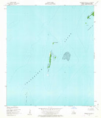
1951 Map of Freemason Island
USGS Topo · Published 1963About this map
Breton National Wildlife Refuge encompasses the fragile, shifting geography of this coastal St. Bernard Parish landscape. The narrow strip of Freemason Island serves as a critical barrier between the open expanse of Chandeleur Sound and the more sheltered waters of Shoalwater Bay. Based on aerial photographs and planetable surveys conducted in 1950, this map records a specific configuration of sandbars and points, including Point Neptune and Point Hope, that are subject to constant reshaping by the Gulf. The hydrography, compiled from Coast and Geodetic Survey charts, details the shallow depths of the surrounding waters and landmarks like Shell Bar and Old Harbor Island Shoal. This remote marine environment is characterized by its lack of roads or trails, defined instead by the natural features of the North Islands and the submerged topography of the inner sound.
Find a feature on this map
9 named features on this map. Tap any name to fly to it.
Don’t see what you’re looking for? This feature index may not catch every label — zoom into the map to look around manually.
Map Details
Editions of this 1951 Freemason Island Map
3 editions found
Other maps of this area

1893 · Chandeleur
USGS Topo · 1:62,500

1951 · North Islands
USGS Topo · 1:24,000

1951 · New Harbor Islands
USGS Topo · 1:24,000
1951 · Stake Islands
USGS Topo · 1:24,000
1951 · Freemason Island
USGS Topo · 1:24,000

1957 · Breton Sound
USGS Topo · 1:250,000

1961 · Breton Sound
USGS Topo · 1:250,000

1982 · North Islands
USGS Topo · 1:100,000
1983 · Black Bay
USGS Topo · 1:100,000
1998 · New Harbor Islands
USGS Topo · 1:24,000