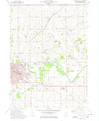
1971 Map of Freeport East
USGS Topo · Published 1978About this map
The eastern reaches of Freeport and the surrounding Lancaster and Silver Creek townships are defined by the meandering Pecatonica River and the confluence of Yellow Creek. During the early 1970s, this area served as a regional hub for Stephenson County, anchored by the Stephenson County Courthouse and a dense network of local institutions like St Vincent Childrens Home and St Josephs Sch. The landscape is a mix of urban development and rural homesteads, with several significant burial grounds including Lancaster Cem, Silver Spring Cem, and Gund Cem marking the legacy of early settlers.
Find a feature on this map
75 named features on this map. Tap any name to fly to it.
Don’t see what you’re looking for? This feature index may not catch every label — zoom into the map to look around manually.
Map Details
Editions of this 1971 Freeport East Map
2 editions found
Other maps of this area

1922 · Oregon
USGS Topo · 1:62,500

1924 · Oregon
USGS Topo · 1:62,500

1932 · Pecatonica
USGS Topo · 1:62,500

1936 · Pecatonica
USGS Topo · 1:62,500

1939 · Freeport
USGS Topo · 1:48,000

1942 · Forreston
USGS Topo · 1:62,500

1944 · Freeport
USGS Topo · 1:62,500

1945 · Forreston
USGS Topo · 1:62,500

1954 · Rockford
USGS Topo · 1:250,000

1955 · Rockford
USGS Topo · 1:250,000